Our moorland and green spaces are being put in jeopardy. support my call to oppose mass housebuilding in Todmorden. Book a place at the meeting below in the article.
Calderdale Council has placed it's "land allocation plans" in the domain for public viewing. The link below links you to a list of policy documents which decide where the Local Authority will allow people to build houses in the future.
http://calderdale.objective.co.uk/portal/planning_services/
A quick read of these shows that whilst the areas allocated as moorland are mostly safe, a great many of the spots of green belt a short walk away from the centre of town are at risk. Such sites are arbitrarily picked by Council-hired youngsters walking around with an electronic map, circling any area they can be bothered to walk to.
Years ago I attended a meeting in the Town Hall in which four policy options were being taken into consideration. The main two were making Todmorden a "principal town" (ie building the rump of houses here) and building the houses around the M62 motorway at the other end of Calderdale.
I favoured the latter, as that would be taking advantage of industry whilst protecting our green spaces. The Liberal Democrats, led by Calder Ward Councillor Battye (who is defending her seat this year, remember that!) supported building the rump of them in Todmorden.
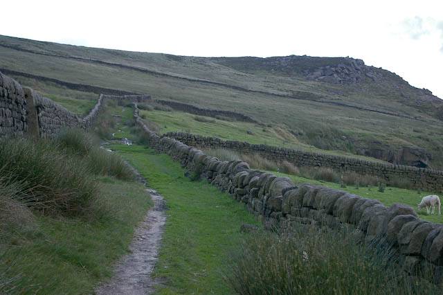
One of the beautiful things about Todmorden is that you do not have to walk more than five minutes before you are in breathtaking country, and amongst the newer houses there are many architectural wonders. It amazes me when people who object so vigorously against agricultural windmills and community wind turbines are so happy to see ugly modern buildings spread up over Todmorden like a rash.
When the May 2014 Candidates for Todmorden and Calder Ward come a knocking, press them for their stand on this issue.
Here is a map listing sites they are eyeing up:
http://calderdale.objective.co.uk/portal/planning_services/shlaa13/apx2a?pointId=1378477739189
Amongst the listed sites for mass-building are:
- The field behind Park Road, facing Meadow Bottom Road.
- Half of the field at Harley Wood, off Stoney Royd Lane.
- Tipside area, between the rail track and the River Calder.
- Eastwood Cricket Ground.
- The green space between Summerfield Road and Woodhouse Road.
- The field between Oak Avenue and Ferney Lee School.
- The field between Dinely Knowl and Higher Ashenhurst Fold.
There is to be a meeting at Roomfield Baptist Church Thursday 6th March 7-9pm to discuss this but you have to register a place with Calderdale to be able to attend.
http://calderdale.objective.co.uk/portal/planning_services/
A quick read of these shows that whilst the areas allocated as moorland are mostly safe, a great many of the spots of green belt a short walk away from the centre of town are at risk. Such sites are arbitrarily picked by Council-hired youngsters walking around with an electronic map, circling any area they can be bothered to walk to.
Years ago I attended a meeting in the Town Hall in which four policy options were being taken into consideration. The main two were making Todmorden a "principal town" (ie building the rump of houses here) and building the houses around the M62 motorway at the other end of Calderdale.
I favoured the latter, as that would be taking advantage of industry whilst protecting our green spaces. The Liberal Democrats, led by Calder Ward Councillor Battye (who is defending her seat this year, remember that!) supported building the rump of them in Todmorden.
One of the beautiful things about Todmorden is that you do not have to walk more than five minutes before you are in breathtaking country, and amongst the newer houses there are many architectural wonders. It amazes me when people who object so vigorously against agricultural windmills and community wind turbines are so happy to see ugly modern buildings spread up over Todmorden like a rash.
When the May 2014 Candidates for Todmorden and Calder Ward come a knocking, press them for their stand on this issue.
Here is a map listing sites they are eyeing up:
http://calderdale.objective.co.uk/portal/planning_services/shlaa13/apx2a?pointId=1378477739189
Amongst the listed sites for mass-building are:
- The field behind Park Road, facing Meadow Bottom Road.
- Half of the field at Harley Wood, off Stoney Royd Lane.
- Tipside area, between the rail track and the River Calder.
- Eastwood Cricket Ground.
- The green space between Summerfield Road and Woodhouse Road.
- The field between Oak Avenue and Ferney Lee School.
- The field between Dinely Knowl and Higher Ashenhurst Fold.
There is to be a meeting at Roomfield Baptist Church Thursday 6th March 7-9pm to discuss this but you have to register a place with Calderdale to be able to attend.
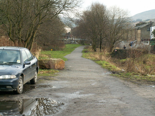
Tipside is one of the areas which Calderdale Council is considering letting houses be built on. This policy must be reversed.
 RSS Feed
